Video by James D. Schwartz / The Urban Country – Music by danosongs.com
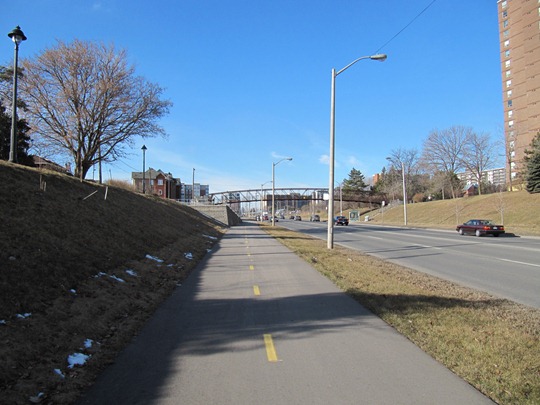
Yesterday I ventured out to the suburbs of Toronto to video record one of my favourite bike paths on Eglinton Ave West in suburban Etobicoke. The 5km+ unobstructed bi-directional bike lanes is a rarity in a city where most unobstructed bike lanes are primarily for recreational use rather than for commuting.
Photo by James D. Schwartz / The Urban Country
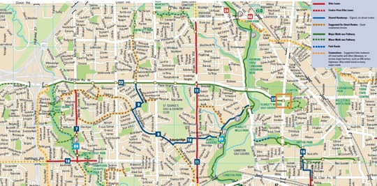
The video shows the entire length of the bike path – from Martin Grove Rd. in the west to Jane St. in the east with playback at 8x the actual speed. You can see in the map below how the bike path ends and there are no bike network connections (ending point is marked by an orange square):
Toronto Cycling Map provided by City of Toronto
Although I’m happy the city has been investing in bike infrastructure in the ‘burbs, it’s unfortunate that this path doesn’t connect to a network of on-road bike lanes or bicycle routes. It basically ends at a major intersection with many cars traveling at 80km/h or sometimes higher (it’s a 60kmh zone, but many cars travel much faster than 60kmh).
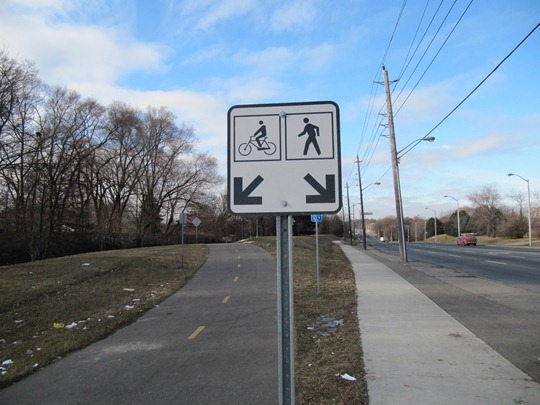
On a positive note, the Eglinton bike path separates pedestrians from cyclists – another rarity in this city.
Photo by James D. Schwartz / The Urban Country
I can’t comment on the volume of cyclists actually using this path because I recorded this on a Saturday morning. But given the fact that I only saw one other cyclist in the 60 minutes it took me to record the video clips, I would guess the path is most likely underutilized during rush hour.
We still have a car culture here in Canada, and people still aren’t willing to give up their cars for several reasons. By building bicycle infrastructure such as this, we are at least removing one of the barriers to getting people on their bikes.
Stay tuned for an upcoming article in the next few days where we will interview a Florida cycling instructor and explore some of the reasons why such few people use their bicycles for transport in North America – even after the infrastructure is put into place.
James D. Schwartz is the editor of The Urban Country. You can contact James at james.schwartz@theurbancountry.com.
Related Articles:
- Bicycle Friendly Workplaces (Jan 2010)
- Winter Cycling in Toronto (Jan 2010)
- Toronto Yearns for Bicycle Superhighway (Dec 2009)
- Barriers to Cycling: Debunking the Myths (Nov 2009)


I like how your blog is starting to gain an identity centered around promoting cycling.
Nice video, though at around 1:50 you starting looking a little creepy… just standing there, not moving, in black and white.
Boyan, my camera has a few different settings: “mildly creepy”, “moderately creepy” and “extremely creepy”.
I was using the “extremely creepy” setting while taking that shot.
Glad you enjoyed my creepiness 😉
Great path – and really, what’s stopping this model from being used elsewhere? Steeles could be like this for much of its length, Dufferin north of the Allen Expressway could also. The model of: road, wide strip of grass or pavement, wide sidewalk, then wider strip of grass on the other side is all over the ‘burbs and could be adapted so easily to road, curb, bike lane, grass, sidewalk. Imagine, for example, what you could do with *this* stretch: http://is.gd/6ZzZx
Agreed Todd, this is definitely a model that could be used on other suburban roads where people are rightfully fearful of riding their bikes.
I couldn’t see these bike paths being much more expensive than the sidewalk – considering they use the less expensive asphalt (vs. concrete sidewalks).
This would give people in the suburbs an alternative option vs. always defaulting to their cars.
The deterrent from doing this on most Toronto arterials is the ubiquitous strip-mall and the horribly designed driveways that come along with them. Drivers entering and exiting through such a bike path is an accident waiting to happen.
Eglinton west was spared this, because it was originally built to be upgraded to an expressway.
Toronto’s new planning guidelines prevent parking lot frontages, but it will be a while before these ugly beasts are extinct.
i used to take this west to east path on my commutes from the west end, it is a great down hill ride from martingrove all the way to Jane St, however from Jane there isn’t a great direct route to downtown.. you have to get creative to weave your way back to bloor st. now if there was a bike path that was paralell to the rail path that went all the way down town would be ideal… however bridges over the humber make for detours again.
Pingback: Getting To The Airport By Bike ← The Urban Country
Hi My name is Allan and I use this path on my commute home from jane & langstaff. I do see cyclist on this route as most combine it with the humber trail.I wish the city would put the same type of path along Steeles ave and north on jane connecting the finch hydro path