Toronto’s fragmented bicycle network (PDF download) by The Urban Country
Toronto is not unlike the vast majority of cities in North America, UK, and Australia when it comes to bicycle infrastructure. Progressive politicians often aim high, but are often met with resistance by motorists and businesses when building bike infrastructure.
Populist politicians pretend they are doing something, but slap in just enough infrastructure just to get the vocal citizens to shut up, and regressive politicians do their best to unravel the small gains made by the progressives.
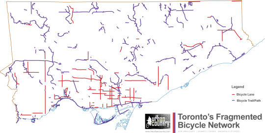
The result? Spotty, disconnected, poorly designed, badly maintained bicycle infrastructure.
The above illustration shows how disconnected and fragmented Toronto’s existing bike infrastructure is (download PDF). The map shows Toronto’s bicycle infrastructure in abstract form with all geographical data stripped.
In 2001, the City of Toronto released its official Bike Plan which “established a vision for cycling in Toronto” and set out principles, objectives and recommendations to “shift gears towards a more bicycle friendly city”. The resulting patchwork of infrastructure is little bits and pieces of the bike plan being implemented over the years.
Asked about Toronto’s Bike Plan, Jared Kolb, Director of Membership for the Toronto Cyclists Union told us:
“Though the City of Toronto’s 2001 Bike Plan at that time was an important step in increasing on- and off-street cycling infrastructure, it was not bold enough in it’s vision for cycling in the city and its implementation to date has moved at a glacial pace. According to the 2001 plan, the 1,000 kms of bikeways were to be completed by 2011. As it stands, only 430 kms have been created. Too often, bike lanes in Toronto don’t connect anything with anything. We owe it to Torontonians to create and implement a network that connects places of origin with places of destination.”
In Toronto, we celebrate small gains one day and fight just to keep those small gains the next day. Motorists and politicians cry doom and gloom when improvements are proposed. They say traffic will become more chaotic and businesses will go under. Frankly, they will say whatever it takes to maintain the status quo.
But despite their catastrophic claims, traffic is minimally affected, and business actually benefit from bicycle infrastructure.
Kolb says the bike plan needs to go much farther:
“While the Bike Plan lays out a vision for a cycling network that is good in principle, the city needs to go much further by creating safer on-street bike lanes (protected bike lanes rather than painted bike lanes) and invest in the completion of our trailways.“
Toronto is indeed in the planning phases for its first physically separated bike lane downtown. This will better connect Toronto’s existing infrastructure if the motion passes through council.
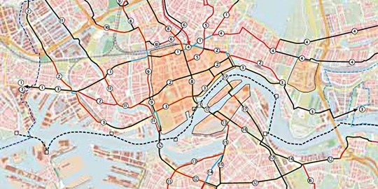
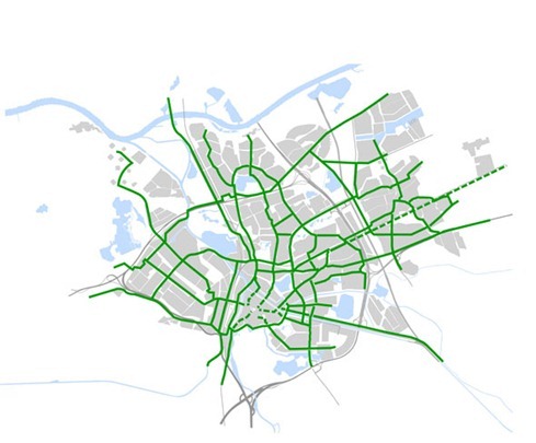
Looking over at the Netherlands for inspiration, a quick look at a bicycle map of Rotterdam – the second largest city in the Netherlands – shows a network of connected bicycle infrastructure:

Image from “Rotterdam remedies a lower cycling rate” on A view from the cycle path.

Image from “More developments in ‘s-Hertogenbosch and Rotterdam” on A view from the cycle path.
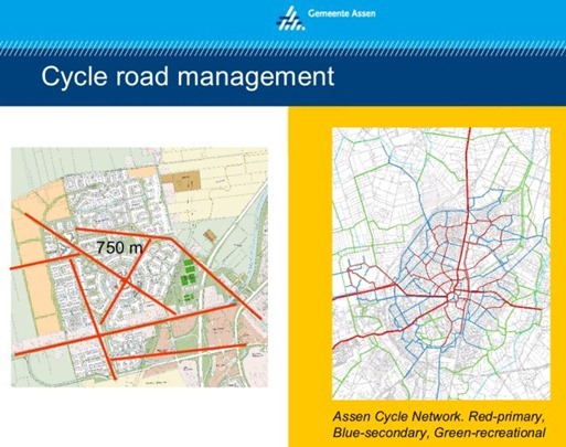
And here you can see a bicycle network in Assen Netherlands:

Image from “The Grid” on A view from the cycle path.
A connected grid of well designed bicycle infrastructure makes bicycling more comfortable for everyone. Thankfully, the lack of connected infrastructure in Toronto hasn’t stopped people from using their bicycles – for a strong contingent of bicyclists is politically vital in order to make positive, effective improvements in our cities.
So don’t wait around for the world to change. Do your part to change it yourself.
Whether you live in Toronto or elsewhere, here are a few things you can do to create positive change in your city:
-
Get out there and ride. We need lots of us out there in order to make improvements
-
Email/call your city Councillor and the mayor to tell them you support improving the bicycle network and physically separated bike lanes. Remind them frequently.
-
Join the Toronto Cyclists Union (or an organization that represents the needs of cyclists in your city)
-
Let businesses know that you rode your bike to the store and tell them that better bike infrastructure is good for their business.
-
Get your friends to start using a bike. Explain the benefits (it’s often faster, healthier, etc)
-
Convince your boss to make your business more bike friendly (bike parking, bike sharing memberships, compensating bike commuters, etc)
James D. Schwartz is the editor of The Urban Country. You can contact James at james.schwartz@theurbancountry.com.
Related Articles:
- Rush Hour in Toronton At –11 Celsius (March 2011)
- Stifling Urban Bicycling in Toronto (Dec 2010)
- Thousands of Bicyclists Snub Toronto’s New Mayor (Dec 2010)
- Toronto Inches Forward At Record Speed (April 2010)
- Dreaming of Segregated Bicycle Facilities (Dec 2010)


Fine article James. And just to be clear. Out of the over 400KM of actual bike lanes that were included in the original plan, we have seen about 80KM. You know, the red lines …
Fine article James. And just to be clear. Out of the over 400KM of actual bike lanes that were included in the original plan, we have seen about 80KM. You know, the red lines …
Toronto’s map kinda looks like Calgary’s –
http://bit.ly/iMG0iz
Toronto’s map kinda looks like Calgary’s –
http://bit.ly/iMG0iz
It’s amazing how much space (width) we have available on most streets in Toronto. In the Netherlands they’d be able to fit in a bicycle highway, sidewalks, trees, and a roadway. I wonder if Toronto politicians look for excuses not to build more bike paths because they either don’t have the money for it or want to spend it elsewhere. But look at other benefits of buidling separate bike paths (besides being safer): more jobs, business created;
a good reason to re-organize and modernize streets; streets looking better and frendlier; attracting more tourists + tourists that discover the city by bike are more likely to find and visit shops and other places.
The map seems to be erroneous. I’ve seen bikes in lots of places not shown on the map.
Is this some kind of joke, like the man who got stuck on the escalator when it broke down and stopped moving … and had to wait hours for repair to come?
The map isn’t erroneous, though the situation isn’t *quite* as bad as it appears on the map. A number of the discontinuities in the trails are places where the trail ends at a park road, and picks up further down — but the park roads are generally low-traffic and well-maintained, so are perfectly safe to bike on. You can get from Lakewhore to Stoneybrook Park without having to leave the park, in spite of the gaps shown on the map.
Still, many of the gaps are real and problematic. Consider Taylor Creek / Warden Woods / St Clair Ravine, which runs east from the Don Valley. The gaps look small, but the golf course between Taylor Creek & Warden Woods means you have to climb out of the valley onto Vic Park and take streets around to Pharmacy to get into Warden Woods; then you have to climb out again and bike along — and cross — St. Clair to get into the Ravine.
James,
We left out park roads, because even though they’re bicycle “friendly”, they’re still roads and are designed for cars.
There are many other bike “friendly” roads in the city, but since we’ve left those out, we’ve left out the ones in the park as well.
The map seems to be erroneous. I’ve seen bikes in lots of places not shown on the map.
Is this some kind of joke, like the man who got stuck on the escalator when it broke down and stopped moving … and had to wait hours for repair to come?
There is nothing erroneous about this map. It shows “true” bicycle infrastructure that exists in the city, which are bicycle trails and lanes.
There is nothing erroneous about this map. It shows “true” bicycle infrastructure that exists in the city, which are bicycle trails and lanes.
The map isn’t erroneous, though the situation isn’t *quite* as bad as it appears on the map. A number of the discontinuities in the trails are places where the trail ends at a park road, and picks up further down — but the park roads are generally low-traffic and well-maintained, so are perfectly safe to bike on. You can get from Lakewhore to Stoneybrook Park without having to leave the park, in spite of the gaps shown on the map.
Still, many of the gaps are real and problematic. Consider Taylor Creek / Warden Woods / St Clair Ravine, which runs east from the Don Valley. The gaps look small, but the golf course between Taylor Creek & Warden Woods means you have to climb out of the valley onto Vic Park and take streets around to Pharmacy to get into Warden Woods; then you have to climb out again and bike along — and cross — St. Clair to get into the Ravine.
James,
We left out park roads, because even though they’re bicycle “friendly”, they’re still roads and are designed for cars.
There are many other bike “friendly” roads in the city, but since we’ve left those out, we’ve left out the ones in the park as well.